It was a “burdensome journey” to reach Yellowstone National Park’s southwestern corner in the 1920s, making it an “almost inaccessible portion of the park,” according to W. A. Lansberry, editor of the nearby Ashton Herald newspaper in Idaho.
Long referred to as the park’s Cascade Corner for its numerous waterfalls, the region is so ignored by the 4 million-plus people who visit Yellowstone each year that the Park Service doesn’t publish entry statistics or man a fee station. Yet, on a September day, the parking lot at the Bechler Ranger Station office is packed with vehicles from around the nation, hauling visitors from as far away as Missouri, Iowa, and Oregon.
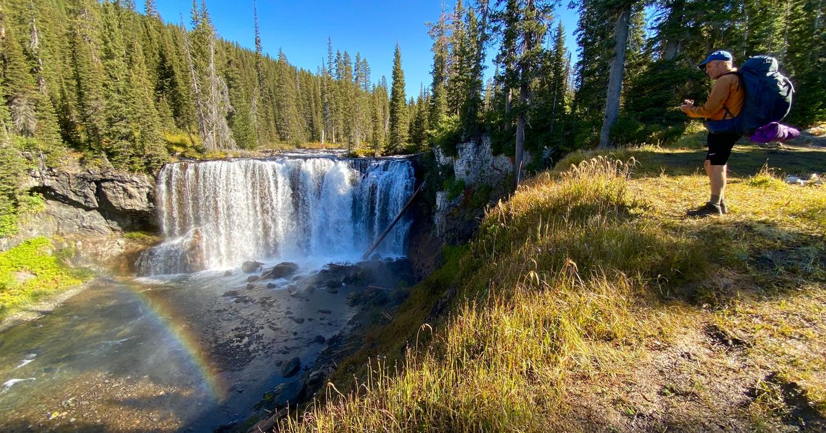
They come to fish the Bechler and Falls rivers, day hike trails to nearby waterfalls, or backpack into the remote terrain seething with hot waters and thermal features.
### Waterfall Wonderland
Between 1981 and 2010, this region averaged more than 4 feet of snow a year. Runoff from the Pitchstone Plateau, which tops out at a height of more than 8,900 feet, feeds 260-foot-tall Albright Falls on the Bechler River. The river seems to plummet abruptly over 100 yards in its canyon section.
The waterfalls are so plentiful because the region is relatively young in geological terms. The Pitchstone Plateau lava flow dates back only 70,000 years. The Bechler River lava is estimated to have spread into the region about 117,000 years ago. Consequently, the Bechler and Falls rivers have not had enough time to wear the lava layers smooth.
After plunging from the plateau, the Bechler River squiggles through a vast meadow that, when wet, becomes an insect factory. To the south, across the grassy plain, the Teton Mountains abruptly rise, the highest peak being Grand Teton, towering at a cloud-skimming 13,775 feet.
“What splendid meadows they are!” wrote William C. Gregg, who explored the area in 1919 with his daughters. “Ten to twenty thousand acres of the best camping country in the world, and every stream is full of native trout.”
### The Big Dam Plans
Despite the beauty of this region and its location inside Yellowstone National Park, Idaho lawmakers in the early 1900s sought to tap the region’s water for a reservoir and carve a road from Ashton to Old Faithful.
The reservoir was first advocated in 1919 along with a 60-foot-high concrete dam that would flood Bechler Meadows. Idaho Rep. Addison Smith, vice-chairman of the public lands committee, told Congress in 1920, “There is absolutely nothing in the way of unusual scenery or other interesting features in this part of the park, but the entire area contains only the ordinary western mountain landscape scenes, such as may be seen along the lines of travel for many miles by any tourist approaching the park from any direction.”
In contrast, William C. Gregg strenuously disagreed in the Hackensack, New Jersey, newspaper:
“I am compelled to say that this does not square with what I found and saw there. I personally visited and photographed between thirty-five and forty falls, cascades, hot springs, and rock formations. This Bechler River valley is the wildest, most level and most beautiful in the Yellowstone National Park.”
Other eastern newspapers, as well as the venerated *Saturday Evening Post*, jumped to defend the park from the Idaho “irrigationists.” “A national beauty spot is in peril,” *The Kansas City Star* proclaimed.
Idaho also sought to dam Yellowstone Lake at its outlet near Fishing Bridge, as well as nearby Heart and Lewis lakes. When Congress balked, Idaho lawmakers returned in 1926 with a plan to trade a 64,000-acre parcel for 12,000 acres in southwestern Yellowstone. By then, the dam was proposed to be earthen, instead of concrete, to “blend harmoniously with the landscape.”
The resulting lake would “make an ideal spawn-taking station and would be valuable for the propagation of fish and as a habitat for waterfowl and other game,” lawmakers touted in hopes of luring support from sportsmen.
It wasn’t until 1931 that the notion of creating a reservoir was finally abandoned, although in 1937 Idaho renewed its efforts to capture Yellowstone Lake water.
### Park Planted Fish in Bechler
This summer, Idaho anglers hiking into the Bechler Meadows praised the region for its great fishing opportunities for “native” trout, including rainbow trout. It is unclear when rainbows were first planted in the Bechler area, but they are now self-sustaining.
Although Yellowstone fisheries management currently stresses native fishes, as early as 1889 the commander of the Army garrison advocated for stocking trout in the park’s fishless streams. The first plants were eastern brook trout, introduced to Glen Creek and the Gardner River above the falls. At one time, an introduction of black bass was attempted but failed.
Soon, park leadership decided adding fish to other streams was important to benefit angling tourists. As a result, the park stocked other waters and began raising fish at its own hatchery.
The native Yellowstone cutthroat trout were, at the time, referred to as blackspotted trout. By 1920, these fish, which weren’t native to the Bechler River, were being stocked in its headwaters as well as the Falls River and its tributaries, according to park records.
Now, the area is part of the park’s Native Trout Conservation Area, meaning there is no limit to how many rainbow trout anglers may catch and keep. However, all native cutthroat trout must be released.
### Auto Lobby Touts Beauty of Region
In 1922, the Idaho State Automobile Association described the region as “a veritable paradise of nature, abounding with the wily trout and his finny brothers.” The group was promoting the creation of a new road through Yellowstone from Ashton to Old Faithful.
Whereas their counterparts promoting a dam saw the region as a mosquito-infested swamp, the auto advocates sang its praises, calling it the wonderland of waters. A road would “open new delights to the lovers of the great outdoors and incidentally provide an Idaho entrance to Yellowstone,” H. W. L. Niemeyer, secretary of the association, proclaimed in a story accompanying a two-page layout filled with photos.
“Words cannot describe adequately these wonder works of Dame Nature,” he extolled.
Congress provided the Park Service with $180,000 to build the 31-mile route. It was surveyed to climb from Cave Falls, located about 23 miles east of Ashton, past the Bechler River to an elevation of 8,249 feet before dropping to Lone Star Geyser near Old Faithful.
Surprisingly, Gregg encouraged construction of the road even though he had vehemently objected to damming the area’s rivers. Yet, roadblocks were continually encountered, with *The Idaho Statesman* finally announcing in 1926 that construction would begin that summer.
When the idea of the road died is unclear, but the arrival of the Great Depression followed by World War II may have distracted Idaho lawmakers from the task. Whatever the reason, even today the Park Service advises travelers that reaching the area “takes additional planning and travel time.”
### Bechler Would Recognize This Place
As a result, the area remains little visited in comparison to the rest of Yellowstone, but no less spectacular.
On a September hike through the vast Bechler Meadows, the Teton Mountains stood like blue sentinels over the vast golden plain. A bull elk bugled behind a pine tree-covered hill. Horsemen laughed from their riverside camp, and a group of women backpackers paused long enough to repatch a blistered heel, munch snacks, and admire the sunny day.
Did they know that the “swamp” had narrowly averted becoming a reservoir?
“In ordinary seasons it is not until late in August that a tourist can cross these so-called meadows with any degree of safety,” Lansberry wrote in 1920. “Then the mosquitoes are so numerous the campers find themselves unable to linger in the vicinity.”
Or were they aware that their backpack route was nearly carved by a roadway 100 years ago?
“Strange as it may seem, there is still a great section of this wonderland of geysers and other phenomena which is still inaccessible to the public because there is no means of access except by packhorse or to those who are sturdy hikers,” wrote Niemeyer in 1922.
Thankfully for preservationists, Niemeyer’s observation still holds true.
In fact, namesake Gustavus Reinhold Bechler may still recognize the place. An immigrant from Germany who became a topographer for the Geological and Geographical Survey of the Territories, he first visited in 1872. From that visit, he drew a map of the sources of the Snake River and its tributaries, one of which still carries his name.
http://www.spokesman.com/stories/2025/oct/24/a-trip-through-time-how-yellowstone-national-parks/